 When I was planning this trip from home, the area I found most intriguing was a region little visited by tourists – the Ixil Triangle (Nebal-Chajul-Cotzal), and the region surrounding – where indigenous culture is still very much alive; an area in the center of the country, high in los Montañas Cuchumatanes.
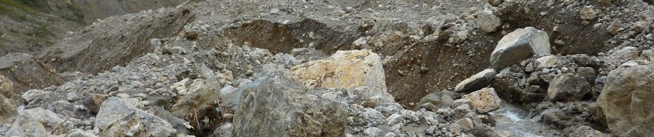
I weighed the wisdom of this journey as I had heard much about the roads here, in particular about the route between Cobán and Uspantán.In 2008 an immense landslide – a complete collapse of the mountain side – had wiped out the dirt road linking them. Because of the extreme geologic instability of this area, the government of Guatemala had not rebuilt this route. Meanwhile the gap had been bridged with detours forced through the landslide debris by the local communities. At times, when there is a lot of rain, the route is claimed to be so dangerous that the drivers will not attempt it, and the passengers must walk the 2 kilometers to where another bus awaits on the other side of the damaged roadway. Of course these facts both concerned me and, at the same time, attracted my interest even more.
I am spending the night at El Portal, just outside Semuc  Champey (pink dot at upper right on map above), above el Río Cahabón, weighing how to use my scant week remaining in Guatemala. The generator powered lights have been turned off for the night, and the maps and guide book are lit by headtorch. I have been to the north of the country – the Peten and the Carribbean – have explored Antigua and many of its surrounding villages, the same with Lake Atitlan. Highest on my list of what I still want to fit into this trip are Copán (the major Maya ruins barely in Honduras) and the Ixil Triangle of central Guatemala.
In the end, it comes down to the sheer logic of where I am and the relative difficulties of reaching the next destination. I am perfectly positioned to head for the Ixil Triangle by way of the questionable route described above. Reaching Honduras and Copán from where I am now is complicated and indirect. I switch off my head light and fall asleep with my door open to the quiet and dark of this off-the-grid ecolodge above the river.
In the morning I haul my pack up the steps to the lodge deck, order a quick breakfast and pay my bill. In exchange for a contribution toward gas, I catch a ride to Cobán with Mark and Wynne, a couple from Arizona. Strangely enough, we share many common experiences from home. They met in my hometown where his mother still lives. She was a student in the same department of the local university as I, and we know many of the same people. And they have been desert vagabonds, spending time in a very remote, little known valley in eastern California, a place also very dear to my heart. Funny how you meet people who are practically neighbors in the strangest places.
They drop me at the north edge of Cobán on their way out of town, by the bus lot. I walk up the drive, past buses headed to every ongoing destination and find the one headed east to Uspantán. Within five minutes I am on-board securing my pack in a rain cover, and we are underway. We stop along the way to pick up more passengers and, as the bus fills, I pass my covered pack through the window to the driver who tosses it up on top where the ayudante ties it on. This is the system, and I totally trust these men to do their jobs with skill – the driver to navigate through the landslide debris, and the ayudante to properly secure all the roof top items.

In Good Hands
I am not particularly worried about the safety of my belongings. My pack is an inconspicuous dirt color, the matching cover makes it look even more dull and uninteresting, covering all the zippers, pockets and straps. And most things of real value are in a daypack which stays at my side.
Though the week before had been constantly rainy, the weather has since improved. The landslide area is about an hour out of Cobán, 1/3 of the way along the route.  This means that we reach it fairly early in the journey. It turns out that my timing is good and though there is mud and areas of road where we must pick a passable route, overall the road is surprisingly good. There are large rocks above and below through the slide area, but none currently in our way.
  The views of the slide are humbling and dramatic, and a small part of me wishes the road might be blocked so I can get photos, but our passage is easy, at least from the passenger’s perspective.
A hint of the driver’s viewpoint is revealed in the volume of the music he plays. This driver adjusts the volume of his radio often – every time we stop, he drops it down, and when we resume it goes up so it is audible above the noise of the engine. But across the slide area, the volume stays low. Then immediately, at the completion of the detour, up it goes as if in celebration of another safe crossing. I appreciate his focus, his skill, the seriousness with which he handles his task. The Guatemalan drivers who pilot the buses on these back roads know their stuff, absolutely. With their knowledge of current conditions, if they are prepared to drive it, I am happy to ride.

Above: Roadside stand, selling fruit and sandwiches.
Below: Small farms tuck into the lush vegetation along the route.

We arrive after a bit less than four hours in Uspantán, a village of about 3,500 people, a place few tourists visit. This is a place where not a word of English is spoken and so it is the absolutely perfect way for me to end a trip where I have spent four weeks relearning Spanish.
Though it is only about 2 pm and I have plenty of daylight remaining, continuing on to Nebaj will involve two more rides. First I will need to catch the microbus toward Sacapulas (see map at top of page). This will drop me at the Nebaj junction (Entronque de Nebaj) where I will wait for the next microbus traveling north between Santa Cruz Del Quiché and Nebaj. By this time it will be nearly dark and I will have spent 11 hours in vehicles. In any case, the population of the Nebaj is 36,000, ten times that of Uspantán, so really, what reason have I to hurry onward?
As they have from my first arrival in Antigua, the street names in Guatemala continue to baffle me. Towns are divided into four regions relative to the central plaza and the street names are repeated for each of the quadrants. So though I have picked the hotel I want and know it is only a couple of minutes walk from where I am, I am at a loss to find my way there. With no street map, it is easier to just pay a tuk tuk driver to take me. I will enjoy wandering and exploring far more once checked in and carrying only a camera and light daypack. In fact, the Hotel Posada Doña Leonor is very, very close, but it takes me two days here before I no longer need to orient myself from the plaza to find my way back.

The church adjacent to the plaza will become my landmark, from where ever I happen to be. Now, on to exploring the village.